I got this idea from a worksheet I passed out supplied by my textbook series. The problem just gave an equation and asked how far someone can see from a specific peak. That's boring.
Act One - Any interesting Questions?
Begin the lesson asking simply Any interesting questions? When I did this with my Trigonometry students immediately they asked where this is, how tall it is, and do people really ski off of that?
The answers are: Lone Peak outside of Big Sky, MT, 11,166 ft, and only the crazy ones.
When you take the tour, a fact is thrown out that I wanted to verify myself, and it brings up an interesting geometry task involving the pythagorean theorem, tangent lines, infinitesimals, and quadratic equations.
So, once the big questions are answered, lets direct the investigation. How many states can they see?
Act Two. The math.
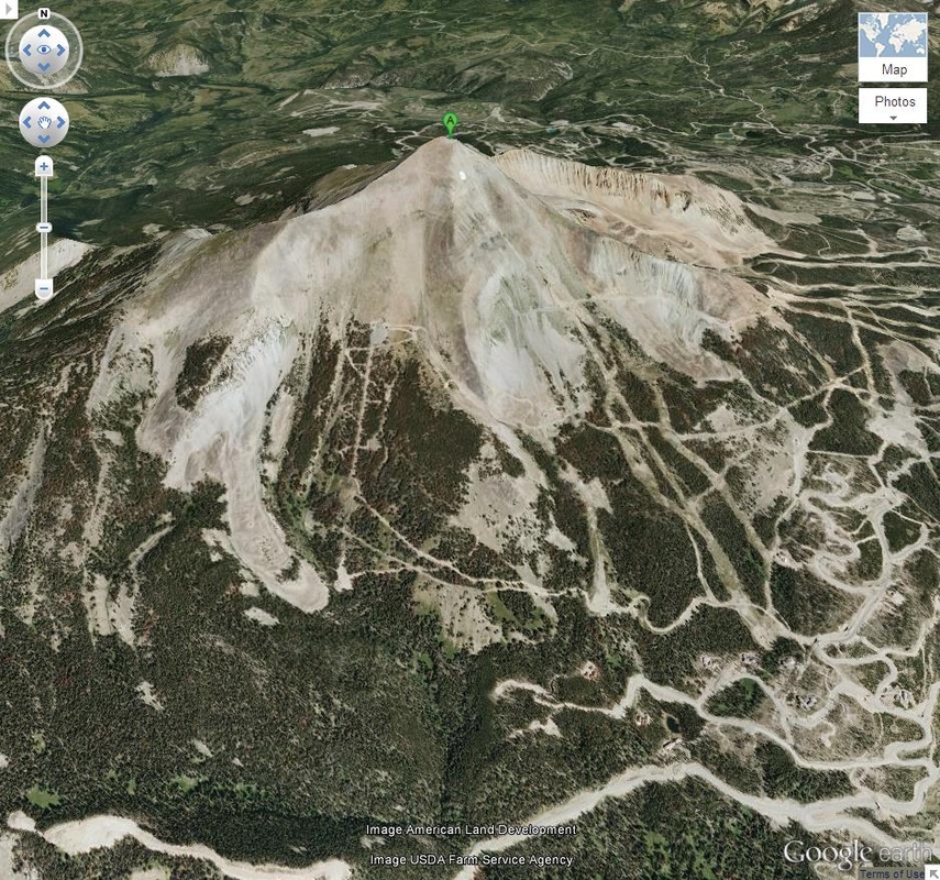
This is a google earth image of Lone Peak during the off season. Those who think about skiing should maybe be a little scared about how much rough insane rock is underneath all of that nice, fluffy, powder.
I allow my students to have free use of a computer on wheels for class questions, and at this point I set them loose on finding the answers to the act one questions themselves. The elevation is 11,166 feet, the most important fact to get (from the math teacher stand point).
From here. The big math starts. Most students would like to confront this problem as a straight up trig problem. I mean, we're in trig class, right? so I plot on the board an awful representation of what's on the projector and label the top as 11,166 ft. I place a little stick figure at the top. I ask what to do now to tell how far they can see. Some students understand drawing a diagonal to the horizon (here there are some quibbles about the mountain ranges around, and those are discussed to see if they matter or not). Well now we need to know an angle looking down. But what if the person isn't looking down?
Here's where it's tricky to keep them believing it's their own idea all along. You need to plant the seed of the idea that the earth is round in their head, and at this altitude, the "roundness" will affect how far they can see. We're dealing with a sphere here, too.
I replace my drawing of the mountain with a drawing of a mountain on top of a sphere, and draw something similar to this:
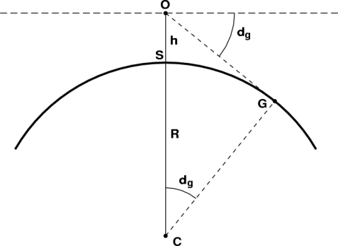
Well now we have a tangent line, which creates a right triangle (honestly I'm amazed at my trig students and their ability to spit out both of those facts without help from me). so we now go about finding the distance from O to G.
OG^2 = (R +h)^2 - R^2
OG = sqrt (R^2 + 2Rh + h^2 - R^2)
OG = sqrt (2Rh + h^2)
At this point I can talk about how R >> h, so h^2 is almost meaningless, but that depends on how well I think the students will buy that.
Using 20,925,524 feet as the radius of the earth, and 11,166 feet as the height of lone peak, the equation yields 129.487 miles.
Now to answer the question, "How many States can you see from there?"
Act Three
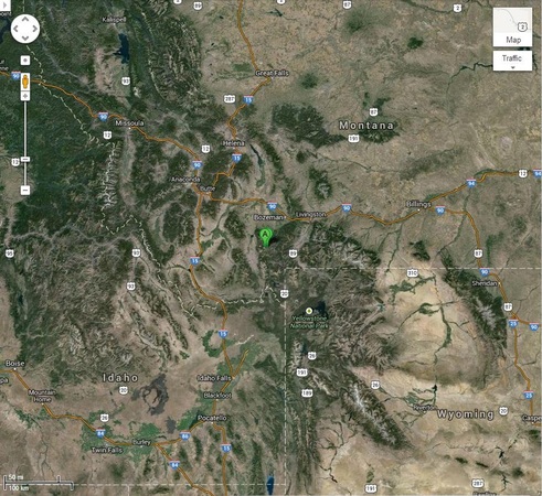
I will either print this out or use it on the board, but using the legend at the bottom of the photo and a compass, the 129 mile radius circle will let the person see into three states (including most of yellowstone park).
Sequels:
How far can you see from the top of Killimanjaro? Everest?
Sequels:
How far can you see from the top of Killimanjaro? Everest?
 RSS Feed
